Shkumbin River: The Fertile & Ancient Valley of Central Albania
Shkumbini river steams from the Valamara mountain range in southeastern Albania. This important waterway is 181 km (112 miles) from its source to its delta in the Adriatic Sea. Despite suffering from pollution, the river still offers some picturesque sites. Such spots include natural marvels such as cataracts, small caves, rock formations, and beaches along the river banks.
The Shkumbin River has a remarkable historic importance for Albania. The river, passing through a steep and narrow terrain along Central Albania, has been of strategic value for centuries. As such, it’s no coincidence that the eastern part of the famous Via Egnatia followed the valley of Shkumbin.

The Course Full Of History Of The Shkumbin River
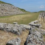
After falling from the Valamara mountains, Shkumbini reaches the fertile region of Mokra, an area rich in cultural and natural heritage. Here, the river flows near the ancient monumental tombs of Selca in the Lower Selca village. Also, in this area is the interesting and intriguing rock formation called “Guri i Kamjes” reachable via some challenging hiking trails. Guri i Kamjes has captivated countless visitors in search of break-through archaeological discoveries and natural amazement.

Further down its course, the river flows under the Goliku bridge. Built in the XVII century near the village of Golik, the bridge is part of the ancient Via Egnatia’s trace. In this part there are multiple outdoor trekkings along the Shkumbin ideal for outdoor enthusiasts. Upon reaching Mirakë village in Librazhd, Shkumbin touches the foots of yet another historic bridge; the Kamara bridge built in the 1600s probably by renowned Albanian architect Kasem Imari. This bridge serves as a focal point for those exploring through hiking trails the outermost parts of the Elbasan county in Central Albania.
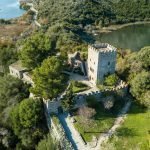
In Peqin and Rrogozhina, Shkumbin flows into its lowest course in very fertile plains. The river drains smoothly in the Adriatic Sea near the village of Vilë Bashtovë. Here stands the Veneto-Ottoman castle of Bashtova, the only such structure in the Balkans built on a full plain. Amidst green fields and laurel forests Shkumbin joins the sea in a picturesque bay.
A Short Profile Of Shkumbin River
The Shkumbin River has a drainage basin of 2,444 sq. km. (or 944 sq. mi.) with an east-west direction across Central Albania. The river has an average discharge of 61.5 cubic meters / second (or 2,170 cubic feets / second). The valley of Shkumbin has supported human civilizations and cultures for centuries. Currently, the river directly affects the lives of some 500,000 people who depend upon it mainly for drinking water and irrigation. The toughest challenge the river faces is the pollution caused by industrial dumps. Thus, a cleaning and drastic intervention is essential to preserve the ecological integrity of Shkumbin river and immediate valley.

Shkumbin’s ancient name was Genusus or Genessus. The upper course of the river marked an important ancient road on top of which the Romans later built the famous via Egnatia. The Romans, beginning in the first century C.E., used the course of Shkumbin to pave most part of the eastern section of the Egnatia road.
The full course of Shkumbin was inhabited in ancient times by different Illyrian tribes. Its lower course and coastal area was inhabited by the tribe of the Taulantii. The middle valley of Shkumbin was occupied by the Parthini, probably a sub-tribe of the Taulantii. Then, the upper valley touched on the mountainous lands of the Dassaretians.
In time, Shkumbin turned into a dialectal boundary; the northern part marked lands where Ghegh dialect of the Albanian language while the southern lands belonged to the Albanian Tosk dialect.
Shkumbin’s Great Importance
At present, Shkumbin allows tourists to conduct different outdoor and sport activities. Explorers can follow multiple hiking trails along all parts of Shkumbin. Others can use the river to point to the historic traces of the via Egnatia. In the Elbasan region, the river’s course is ideal for an average level of rafting both for amateurs and professionals. Such sport initiatives are important to help reduce waste dumping in the river. If authorities and stakeholders reduce all the waste, Shkumbin can reach its full potential in outdoor and recreational tourism.
Shkumbin is still a main communicating corridor of Central Albania. It connects the hilly and mountainous hinterland with Myzeqeja, Albania’s largest plain and the nation’s “granary”. The waterway connects inland with the Divjaka’s Adriatic sea coast and potential small ports in that area near its mouth.
* Shkumbin river features in our top 10 Albanian rivers *


